“I still need to cross Attabad before I reach home” – so our Shimshali travel companion commented matter-of-factly. We had just spent ten days walking along the Pakistan–Afghanistan border, and the best part of the last two days being jostled around in jeeps. Now we were in Karimabad, the tourist hub in central Hunza, and it was time for goodbyes. Yet the ninety-minute boat journey between Attabad and Gulmit that lay ahead for our companion before he reached his village was something no local looked forward to. Maybe I was imagining it, but it appeared that the thought of the crossing compounded his exhaustion.
“Attabad Lake” was formed following a massive landslide in upper Hunza on 4 January 2010 which swept away the village of Attabad and severed the region’s main transport artery, the Karakoram Highway (KKH); the highway is popularly considered a present-day variant on a historic Silk Road (Urdu: Shahra-e-Resham). The aftershocks of the Attabad disaster affected all of upper Hunza’s twenty thousand residents. Not only had debris from the landslide buried the KKH, it also dammed the flow of the Hunza river. By the start of summer, the water had extended twenty kilometers (and become up to a hundred meters deep in places); upriver agricultural land and villages were flooded.
The Attabad disaster manifested as a new violent reality for locals: there was destruction of habitat and community, loss of land and erosion of livelihoods, and erasure of vital infrastructure, such as the arterial road and the essential mobilities it had previously sustained.
The Karakoram mountain range in northern Pakistan is the most heavily glaciated region of the world outside of extreme latitudes (Hewitt 2006). The Karakoram – and the western terminus of the Himalaya – make up Gilgit-Baltistan, an administrative unit home to about two million people. While mobility across the region is facilitated by roads, access depends on the road – usually there is only one – being passable; hazards such as landslides and flooding can sever vehicular access to and within Gilgit-Baltistan. Today, nearly all the towns and villages in Gilgit-Baltistan can be reached by vehicular transport.
Connecting the Karakoram
One all-weather road, the KKH, connects Gilgit-Baltistan to down-country Pakistan. The lower stretches of the highway follow the Indus, before the road branches towards Gilgit Town (pop. 200,000). North of this administrative capital, the road makes its way, via Hunza and upper Hunza – following the eponymous Hunza river – to Khunjerab (4696m) on the Pakistan–China border, where the KKH connects to the Chinese road network. Similar to other states that border China, road connectivity to the Middle Kingdom is seen as engendering economic prosperity.
Two facts about the Attabad disaster must be foregrounded: First, the Attabad landslide had been predicted by geological surveys (Khan 2009; Kreutzmann 2010; Cook & Butz 2013: 372) as so-called natural disasters frequently are. Second, the cost of the slow state response – in terms of providing acceptable compensation for loss of land and livelihood – was borne primarily by the people of Attabad, foremost of which were the nineteen individuals who lost their lives when their homes were swept off the mountainside. Additionally, for years subsequently, scores of families were forced to seek refuge in temporary shelters; many of those displaced from Attabad complained about the lack of adequate compensation. As late as 2016, I met people displaced by the disaster who were still sheltering in tents, with no end to their precarity in sight.
Silk Road by Boat
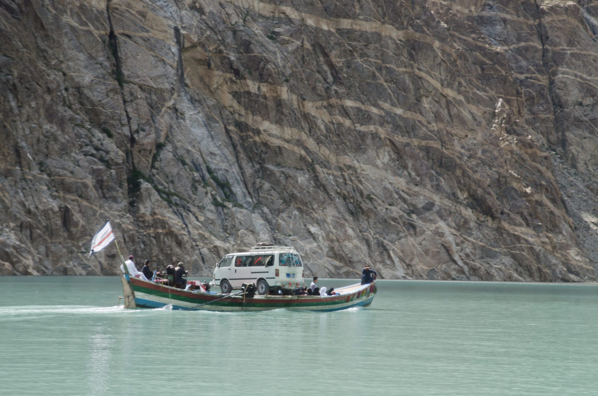
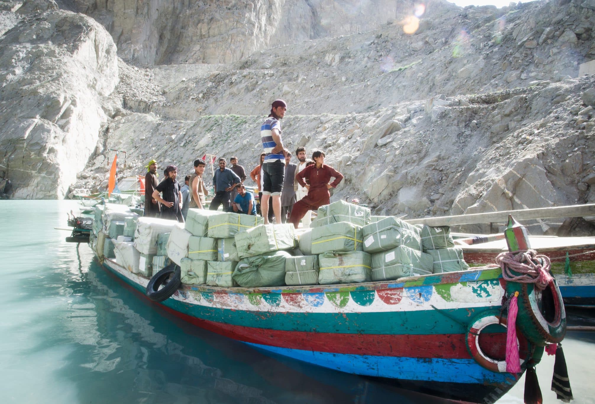
The construction of a bypass road with the necessary tunnels and bridges took five years. Aggravating the disaster was the fact that the only way across the new lake was by open boat. About sixty vessels, most run by private operators from outside Gilgit-Baltistan, served as a lifeline connecting upper Hunza to the rest of the country. Although the cost of travel was within reach of most – it remained steady at PKR 100 (approximately US$1) per person – getting across depended on the availability of a private, for-profit service.
Thus, a new political economy around essential transport had been imposed on the region.
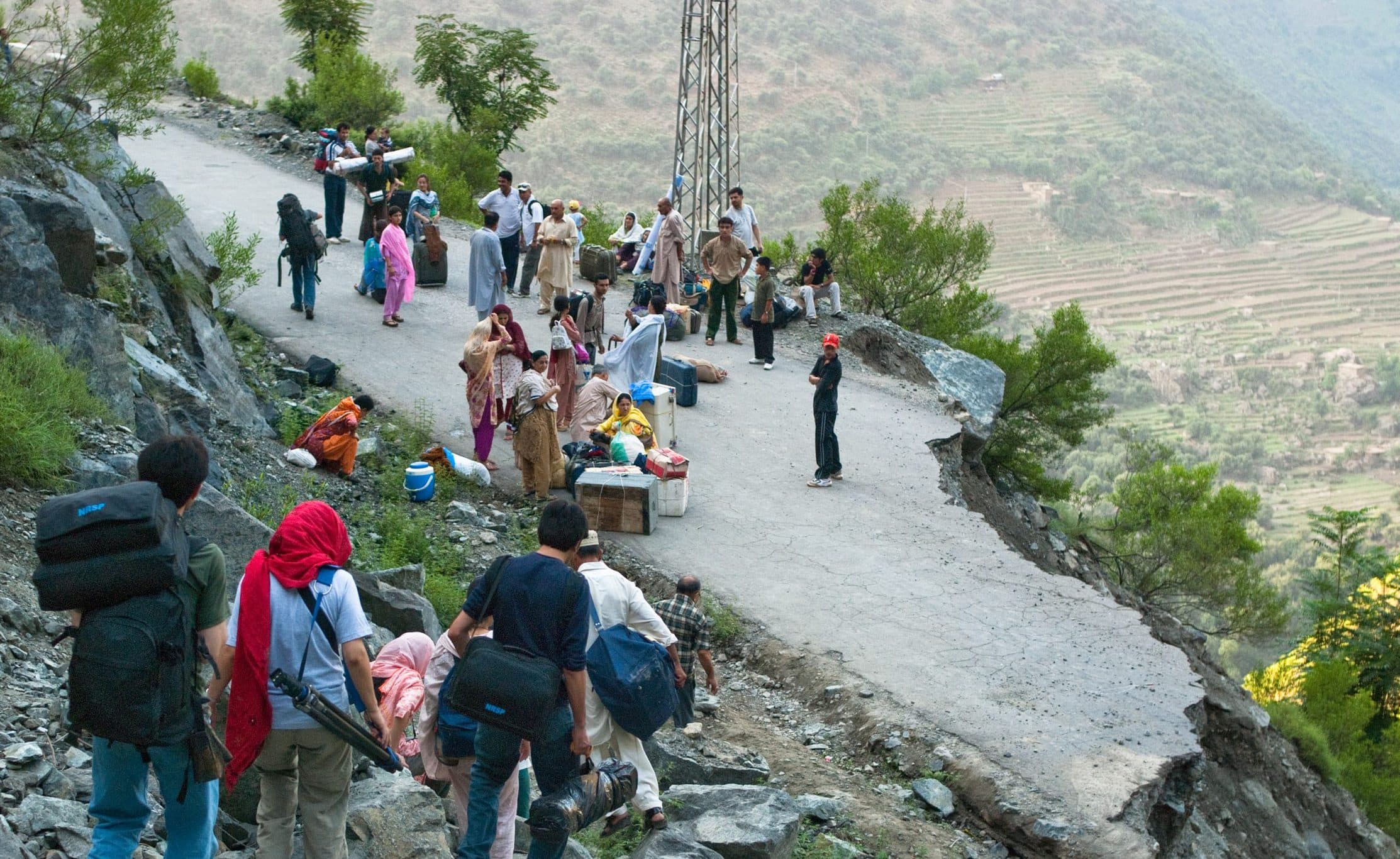
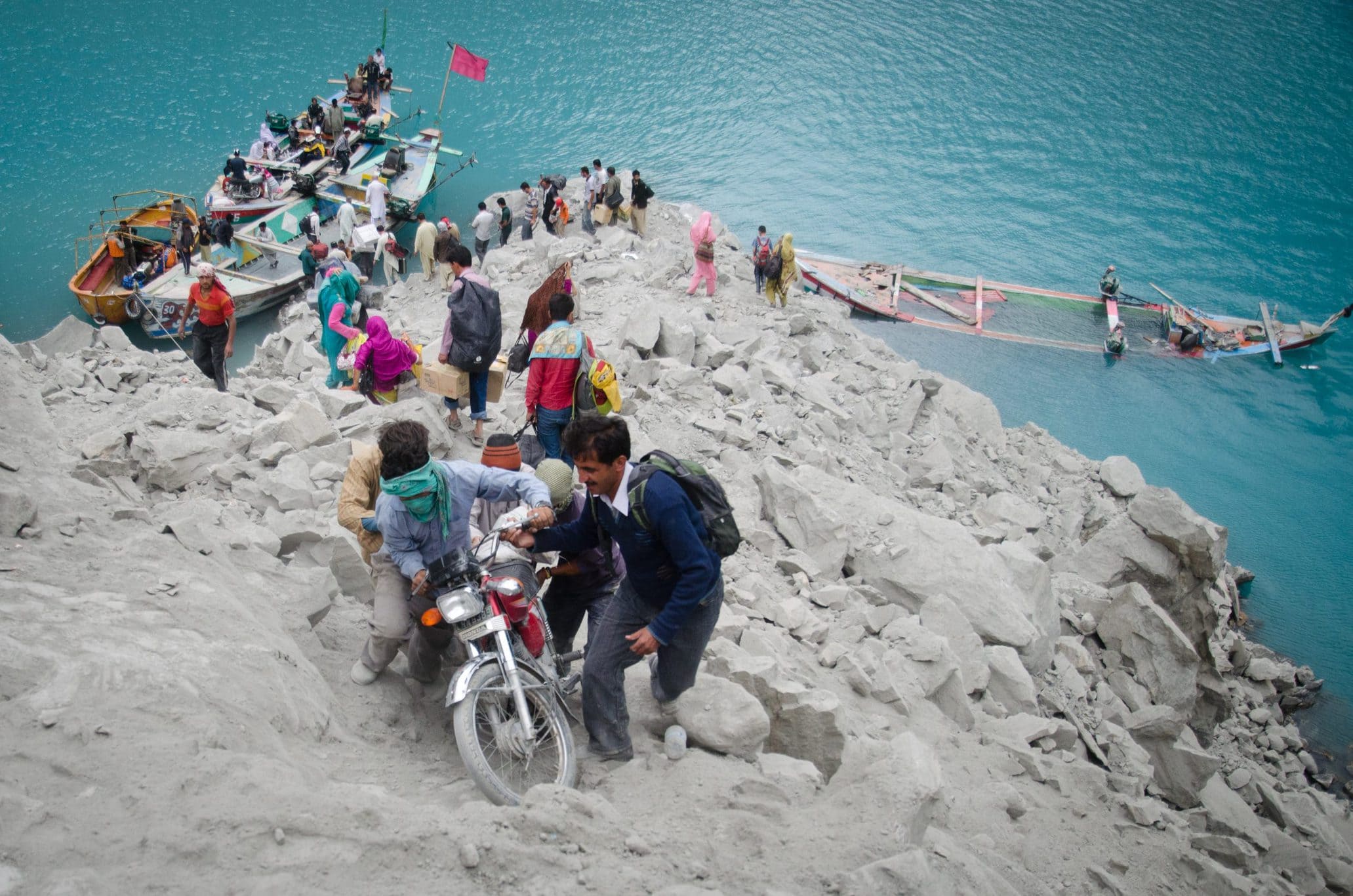
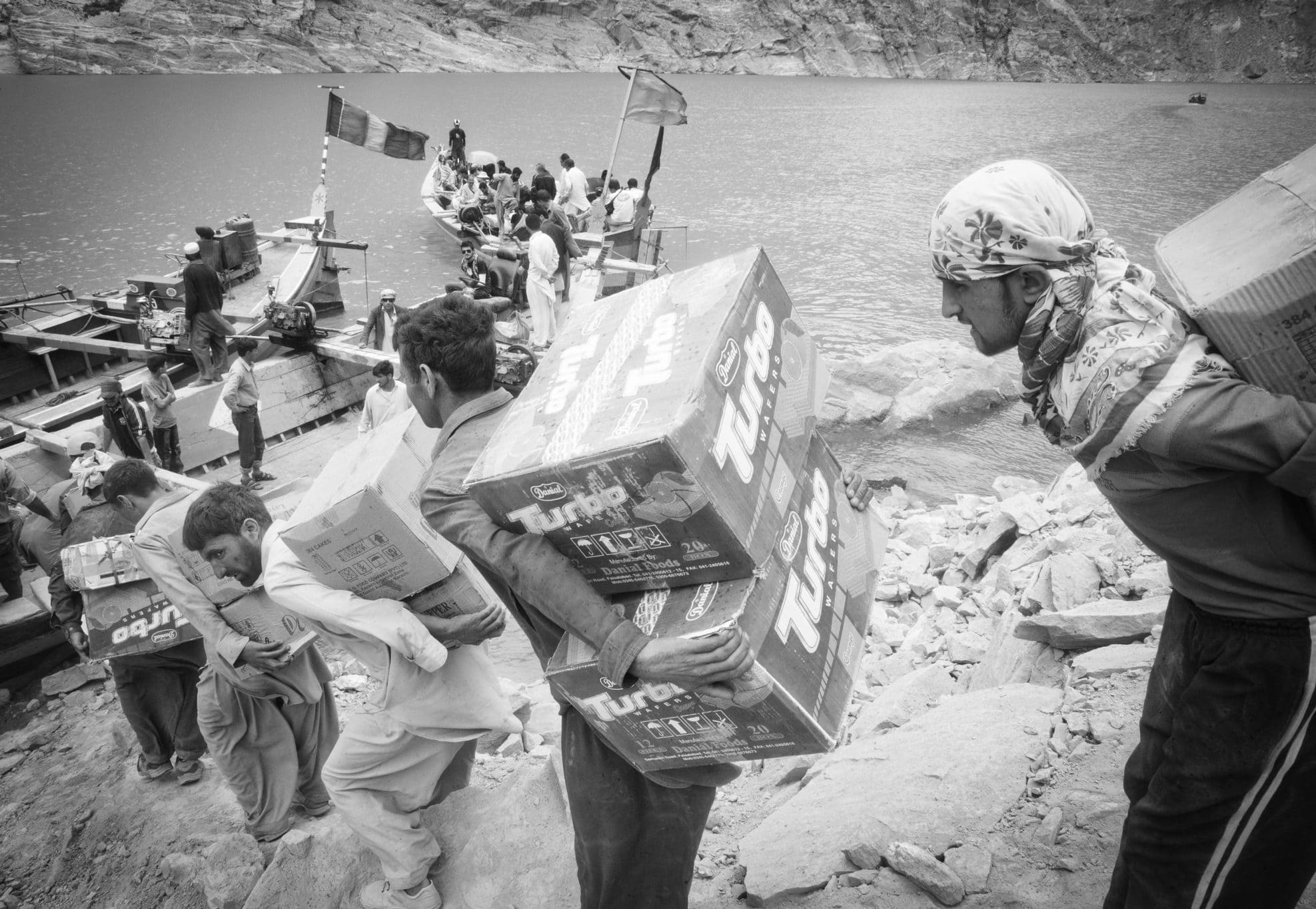
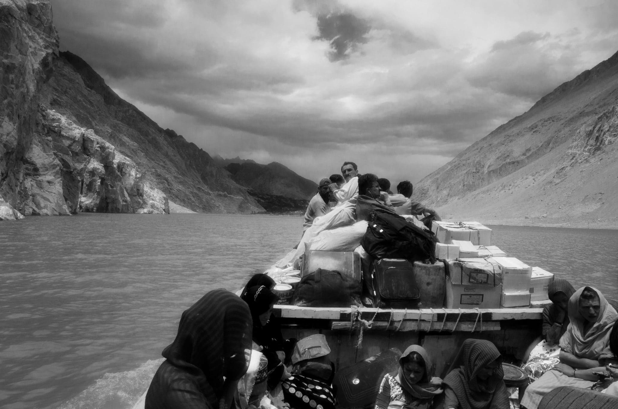
A dock was never constructed; boats daisy-chained to other boats served this function. To cross Attabad Lake, as the reservoir came to be known in common parlance, one had to travel until the road disappeared under landslide debris on the south side or vanished into the water on the north side. Reaching the next departing boat required walking across moored boats and clambering among cargo. Upon reaching the other side, this process was repeated.
For residents of north Hunza, boats became the link connecting them to public services and markets in down-country Pakistan. A distance that could previously be covered in an hour by road, could now become a half-day ordeal. Locals faced these obstacles stoically, although more than one person I spoke with mentioned how difficult the journey was for the elderly or the sick. (The journey was particularly perilous in winter, when stretches of the water froze). The roar of the diesel engine ensured no one conversed during the ninety-minute journey – boats crowded with silent people drifted over vanished fields, past waterlogged orchards and sunken villages.
Paradoxically, as early as 2012 Attabad Lake was being promoted as a tourist attraction. Billboards featuring its cobalt blue waters appeared in Karimabad, enticing visitors to the disaster site. We found Attabad haunting and depressing, my spouse and I confessed to local acquaintances after our first crossing of the young water body; our local friends were visibly relieved, grateful for the acknowledgement that Attabad was seen as more than a tourist attraction by outsiders such as ourselves.
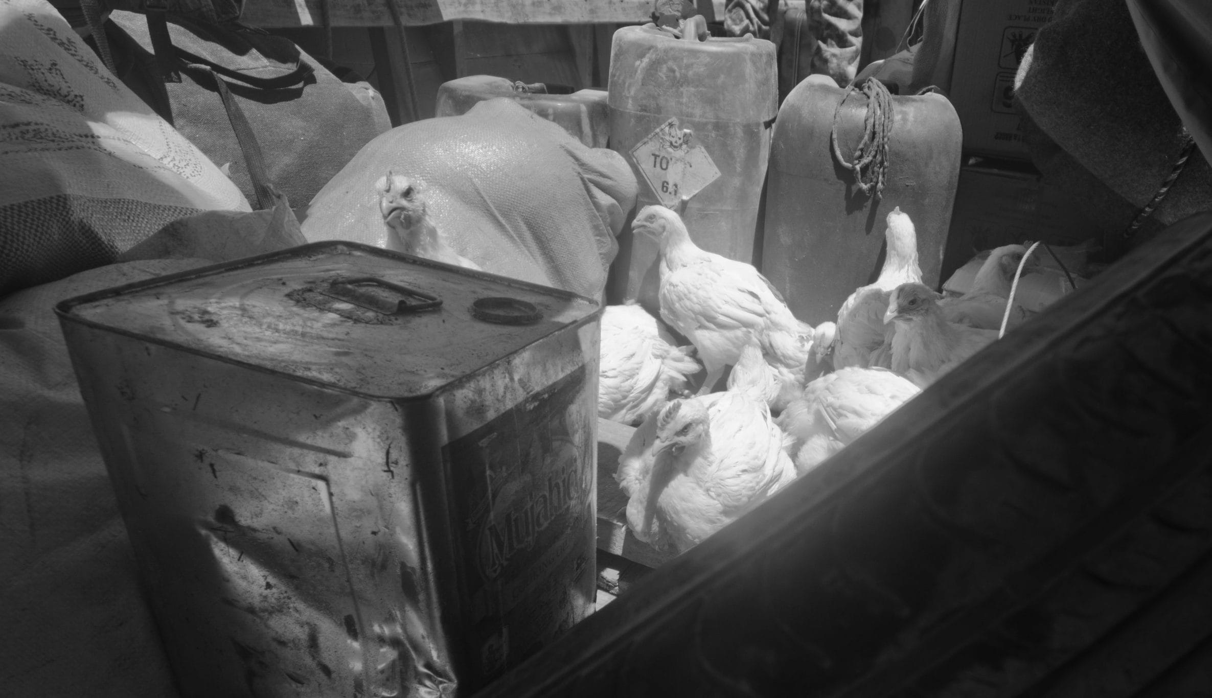
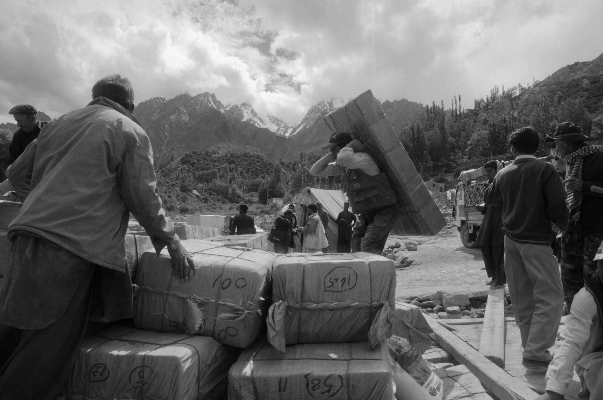
Besides people, the boats we traveled on were ferrying medicine, motorbikes, diesel, tires, construction materials, foodstuffs, bottled water, poultry – the unremarkable cargo of everyday life. This engendered a new labor regime, as everything from daily consumables, household supplies, vehicles and fuel, and construction material was laboriously loaded onto and unloaded from boats. No part of this process was mechanized. While hundreds of wage laborers appeared on the scene in response, this was no Eldorado for anyone.
Rather, sheer physical toil compensated for the disappearance of vital infrastructure, the rupture effect of the disaster compounded by the incongruity of boat travel through the Karakoram, a high-altitude desert.
The China Trade
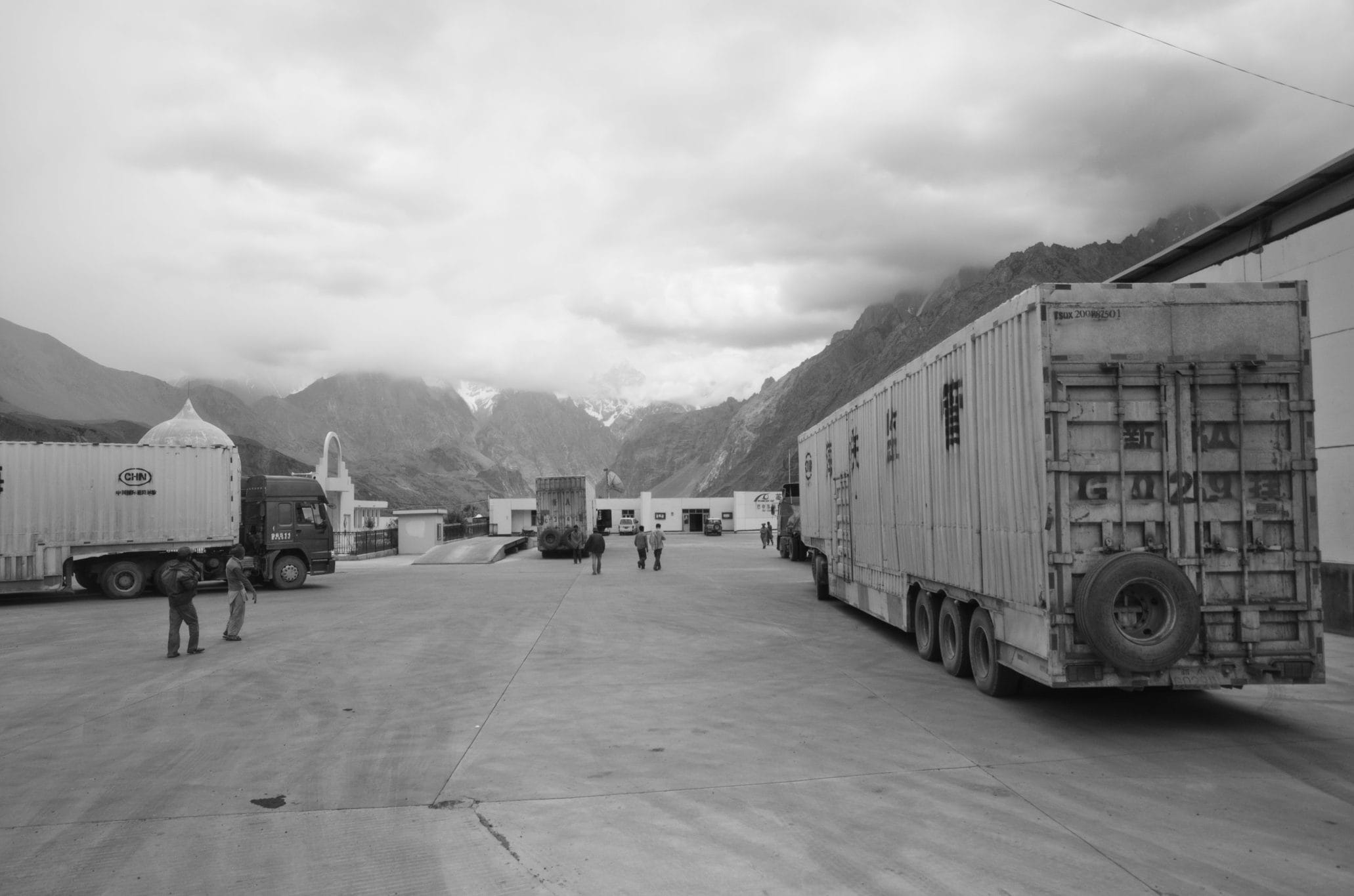
Besides connecting Gilgit-Baltistan to down-country Pakistan, the Karakoram Highway also served as a conduit for overland China trade. While overland routes only ever constituted a fraction of Pakistan’s commerce with China – the majority of which is seaborne – independent traders had benefited from shuttling goods from Xinjiang since the 1980s. For many traders, in particular those who operated with tight margins, the additional cost of boat transport made importing goods from China unviable (Karrar 2013). In the years leading up to the Attabad disaster, I began observing a growing number of Chinese-manufactured goods for immediate consumption in local markets: fruit juice and snacks, soap and detergent. These were high-bulk, low-value items, peddled by locals, their provenance identifiable by Chinese and Uyghur script. After the Attabad landslide, this flow dried up and did not resume. The loss in earnings through cross-border trade was thus another precarity created by the disaster (Sökefeld 2012). Traders importing goods in larger quantities continued to do so, although they were usually not from Hunza or neighboring locales. These goods were also destined for wholesale markets, and comprised manufactured items such as shoes or clothing.
Postscript: Dystopia?
In September 2015, the Attabad bypass was inaugurated; the informal labor that had coalesced at the site of the disaster vanished as quickly as it had appeared. In the years that followed, Pakistan’s dependency on China increased, and Gilgit-Baltistan was now projected as a gateway on the road to bilateral prosperity. Simultaneously, Pakistan saw soaring domestic tourism, concomitant with an emerging middle class and a nationalistic mediascape that celebrates the northern regions, once considered distant and inaccessible.
With memories of the disaster and the resultant toil fading, Attabad acquired new meaning: it now featured in television commercials, music videos and cooking shows with chefs preparing local delicacies aboard boats as they gently bob on the water.
Cyberspace has also played a leading role in the remaking of Attabad (Farrukh 2019). At the place itself, on any given day, visitors can be seen lounging at the many lakeside restaurants, riding pleasure boats and jet skiing while container trucks from China rumble behind.
References
Cook, Nancy and David Butz. 2013. “The Atta Abad Landslide and Everyday Mobility in Gojal, Northern Pakistan.” Mountain Research and Development 33 (4): 372–80. https://doi.org/10.1659/MRD-JOURNAL-D-13-00013.1
Farrukh, Syed Khuraam. 2019. “Social Media Representation of Gilgit-Baltistan, Pakistan, and their relation to the Metropolitan Domain: The Case of Attabad Lake.” Unpublished MA Thesis, Brock University.
Hewitt, Kenneth. 2006. “Glaciers of the Hunza Basin and Related Features.” In Karakoram in Transition: Culture, Development and Ecology in the Hunza Valley, edited by Hermann Kreutzmann, 49–72. Karachi: Oxford University Press.
Karrar, Hasan H. 2013. “Merchants, Markets and the State: Informality, Transnationality, and Spatial Imaginaries in the Revival of Central Eurasian Trade.” Critical Asian Studies 45 (3): 459–80. https://doi.org/10.1080/14672715.2013.829315
Khan, Zulfiqar Ali. 2009. “Cracks in Mountain worries Attabad People.” Pamir Times, 7 March. https://pamirtimes.wordpress.com/2009/03/07/cracks-in-mountain-worries-attabad-people/ (accessed 27 May 2019).
Kreutzmann, Hermann. 2010. “An Inevitable Disaster” Himal Southasian 23 (6): 24–25.
Sökefeld, Martin. 2012. “Visualizing Disaster: Gojal after the Attabad Disaster in Northern Pakistan.” Tsanta 17: 212–24.
Sökefeld, Martin. 2012. “The Attabad Landslide and the Politics of Disaster in Gojal, Gilgit-Baltistan.” In Negotiating Disasters: Politics: Representations, Meanings, edited by Ute Luig, 176-204. Frankfurt: Peter Lang Verlag.
Feature image by Hassan H. Karrar.
To peruse all issues of Roadsides, visit the journal’s website: https://roadsides.net